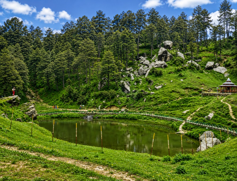
Jalori Pass, an offbeat Himalayan corridor between Kullu and Shimla
A forested mountain pass at 3,120 metres connecting the Kullu Valley to the Shimla region through Banjar Valley — deodar forest, alpine meadow, and a high-altitude lake trek, positioned as a low-density alternative to Himachal's more saturated circuits.
Landscape & Cultural Context
OverviewJalori Pass sits inside dense cover of deodar, pine, oak and fir that holds its colour through every season — green and wildflower-lined from spring through summer, snow-bound from December to February. Clear-day views extend to the Dhauladhar and Greater Himalayan ranges, with misty mornings and forest trail conditions that photograph well year-round.
For centuries the pass functioned as a working trade route between remote villages of Kullu and Shimla districts, and that function is still legible in the region today: local fairs, village-level festivals, and everyday foot traffic between settlements.
The Jalori Mata Temple near the pass remains an active shrine where travellers pause before continuing their route — a point of cultural interest rather than a staged photo stop. Itineraries built around Jalori Pass can credibly position it as a living cultural corridor, not a manufactured heritage site.
This combination — working trade history, active local worship, low visitor density — is what separates Jalori Pass from higher-traffic Himachal circuits and is the core positioning point for itinerary design.
Key Attractions
Within reach of the passJalori Pass Viewpoint
Panoramic sightlines over forested valleys and Himalayan ridgelines, with direct road access — suitable for non-trekking itineraries and short-stop photography.
Serolsar Lake
A high-altitude lake roughly 5 km from the pass, reached on foot through forest trail. Regarded locally as sacred; known for still, clear water.
Budhi Nagin Temple
Standing beside Serolsar Lake, an active local place of worship and a natural pairing with the lake trek on a single-day itinerary.
Shoja & Jibhi
Nearby villages functioning as the main homestay and café base for the area, with easier road access than the pass itself.
Tirthan Valley & Chehni Kothi
River valley and a landmark multi-storey timber-and-stone tower, both within short driving distance for extended-stay circuits.
Great Himalayan National Park
UNESCO World Heritage Site adjoining the region, relevant for biodiversity-led and long-format trekking programmes.
Activities & Seasonal Variation
Programming notesThe Serolsar Lake trek is the anchor activity for most itineraries — forest trail, moderate grade, wildlife and flora visibility en route. Winter shifts the pass toward snow trekking; summer and autumn favour road-trip and motorcycle circuits along one of Himachal's more technical mountain routes.
Wildlife, Cuisine & Local Craft
Ground experienceWildlife — The surrounding forest and adjoining Great Himalayan National Park support Himalayan black bear, barking deer, Himalayan monal, pheasant species, langur, fox, and a wide range of birdlife, relevant for naturalist-led programming.
Cuisine — Village homestays and cafés serve Himachali staples — Siddu, Dham, Madra, Babru, Chha Gosht, rajma, fresh trout, local honey and herbal teas.
Craft & retail — Jibhi, Banjar and Kullu town supply Kullu shawls, handwoven woollens, wooden handicrafts, traditional caps, honey, herbal goods, dry fruit and artisan souvenirs — useful reference points for shopping-inclusive itineraries.
Access & Logistics
Routing reference| Mode | Nearest point | Distance / note |
|---|---|---|
| Air | Kullu–Manali Airport, Bhuntar | Approx. 60 km from the pass |
| Rail (broad gauge) | Chandigarh | Nearest broad-gauge railhead |
| Rail (narrow gauge) | Joginder Nagar | Nearest narrow-gauge railhead |
| Road | Shimla, Kullu, Banjar, Jibhi, Shoja | Regular taxi and bus service in-season |
Seasonality Calendar
Route planningApril–June and September–November offer the most stable trekking and road conditions. December–February brings snowfall and a distinct winter product, with occasional access restriction on heavy-snow days worth flagging in itinerary terms and conditions.